Get in touch
Work

Selected work

Projects spanning source-to-sea water systems across five countries — arid-region utility planning, coastal and riverine hydraulics, field science, and the analytical software that ties them together.

13

Projects

5

Countries

10+

Years

Geography

Source-to-sea work across the United States, the Kingdom of Saudi Arabia, Peru, and Panama. Select a marker for detail.

  • Practice base
  • Hydraulics, coastal, research
  • Planning and infrastructure

Planning & Strategy

5 projects
2023–2026Kingdom of Saudi ArabiaENOWA / NEOMcompleted

Regional Water Demand and Supply Planning Model

A versioned node-based demand and supply planning model spanning 2024–2080, informing water infrastructure investment and phasing.

Conceived, built, and operated as sole developer. It covers regions, sectors, water types, wastewater generation, reuse, storage, and supply-demand balance, and grew with each master-planned region — from loose concepts to monthly operational detail — while preserving planning versions, assumptions, lineage, and forecasts. Inputs from roughly 10–20 regional and sector teams became consistent model structures supporting desalination, wastewater, reservoir and storage strategy, surplus-water availability, and high-level CAPEX and OPEX evaluation.

2024–2080
Planning horizon
10–20
Contributing teams
Sole developer
Role
2025Kingdom of Saudi ArabiaENOWA / NEOMconcept

Managed Aquifer Recharge Program Concept

Originated a managed-aquifer resilience concept and wrote the principal internal proposal behind it.

The concept targeted long-term system resilience for a major industrial zone. The proposal developed the demand, surplus-water, storage, technical, and high-level financial framing behind it, then carried the case across engineering, executive, and regulatory audiences. Advanced internally; not externally funded during tenure.

Originator
Role
Internal concept
Status
2025South AfricaSouth Africa–UK PACTcompleted

Climate-Finance Consortium and Full Proposal

Co-led a full proposal to the 2025 South Africa–UK PACT call, assembling and structuring an eight-partner consortium.

Developed with a South African engineering firm, the submission defined how the consortium would function: partner roles, work packages, reporting relationships, organogram, workplan, and budget, alongside the theory of change, risk register, monitoring framework, and capacity-building approach. Submitted in full; not awarded. It remains the clearest illustration of the coordination problem this practice exists to solve.

Co-lead
Role
6
Partners added
Submitted
Outcome
2022–2023Southwest Florida, USAcompleted

Septic-to-Sewer Expansion Strategy

Scenario and predictive analytics across tens of thousands of wastewater network configurations.

Evaluated septic-to-sewer expansion strategies across three counties, assessing cost, sustainability, feasibility, and planning trade-offs for each candidate configuration. Frameworks were aligned to state grant requirements so results could strengthen municipal funding proposals directly.

Tens of thousands
Configurations
3
Counties
2016Panamacompleted

Gravity-Fed Community Water System

Hydraulic design and construction support for a remote mountain village water supply.

Site assessment, hydraulic design, and construction support for a gravity-fed distribution system — the opposite end of the scale spectrum from giga-project utility planning, where the analytical questions rhyme.

Gravity-fed
Approach

Hydraulics & Coastal

4 projects
2021Charlotte County, Florida, USAcompleted

Estuarine Circulation Field Campaign, Matlacha Pass

Shipboard and moored velocity profiling across ~20-hour tidal cycles to explain ecological risk and fish-kill events.

Field measurement and hydrodynamic analysis of estuarine circulation through Matlacha Pass, capturing full water-column structure and pairing it with CTD casts for salinity and temperature. The resulting analysis of circulation and bottom dissolved-oxygen dynamics informed stakeholder understanding of ecological risk and observed fish kills.

~20 h cycles
Survey duration
ADCP · CTD
Instruments
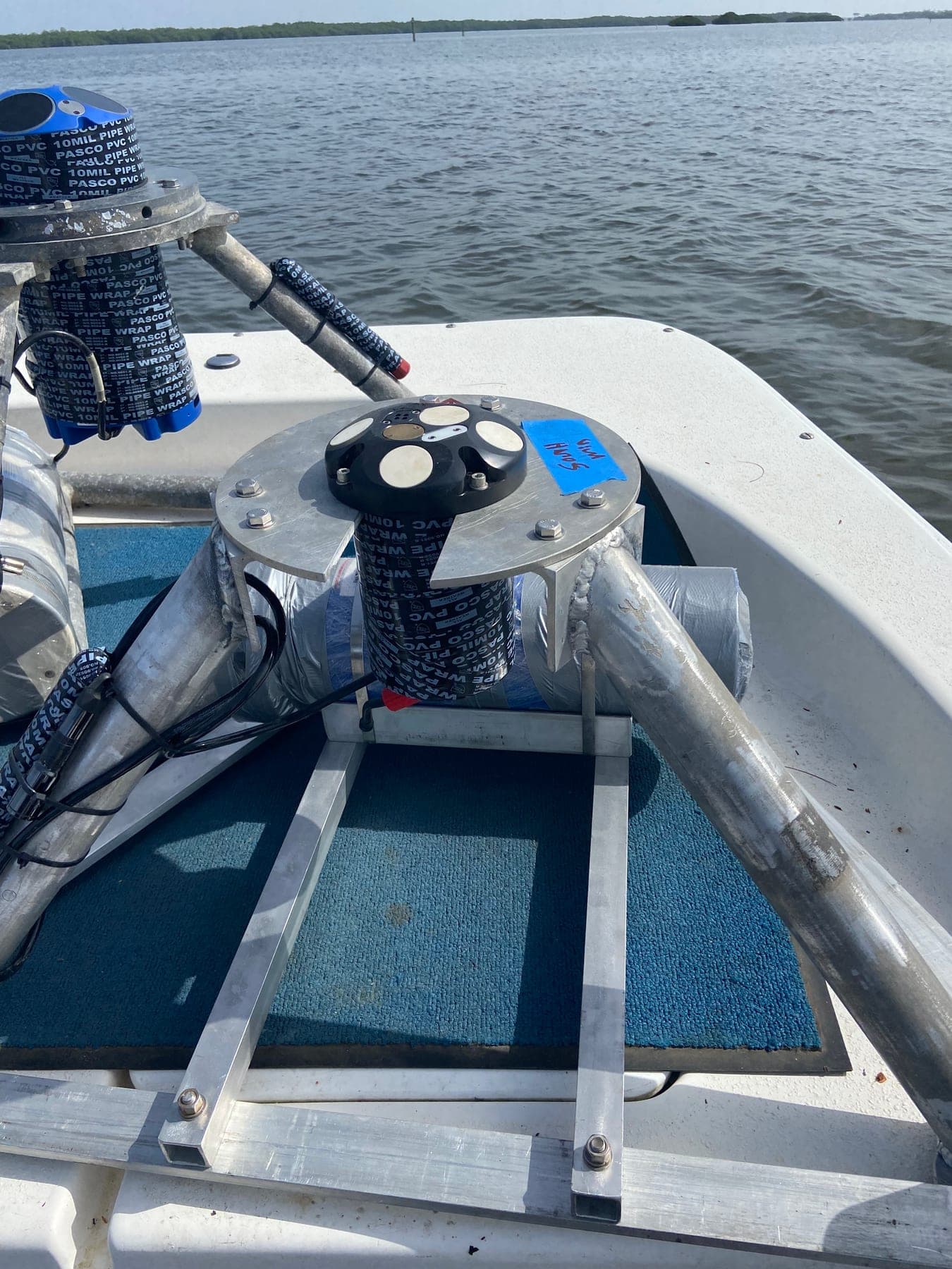
Acoustic Doppler current profilers mounted on bottom frames prior to channel deployment, configured to resolve full vertical velocity profiles.
Fig. 3Acoustic Doppler current profilers mounted on bottom frames prior to channel deployment, configured to resolve full vertical velocity profiles.
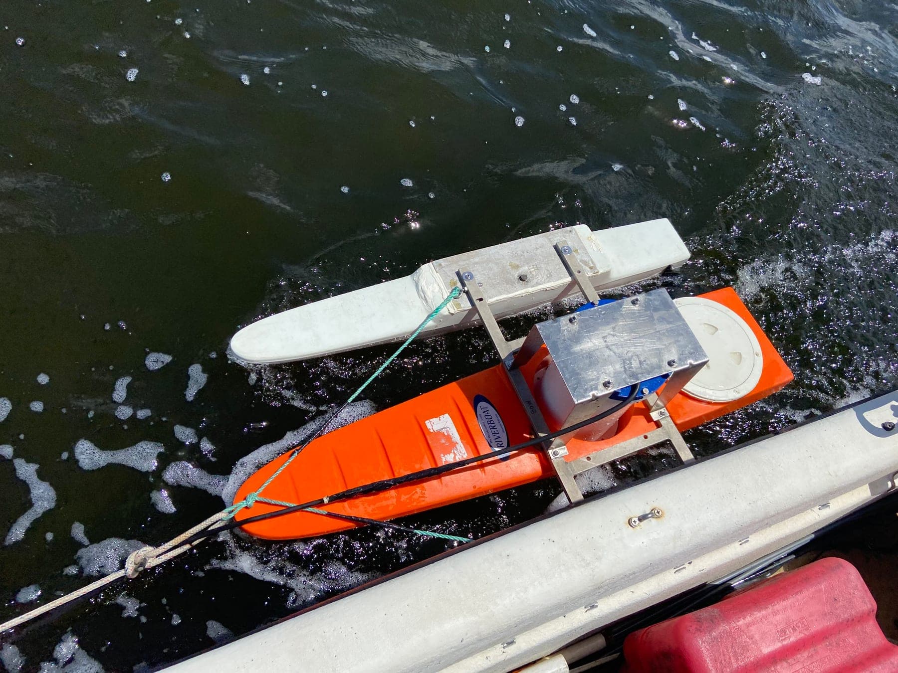
Towed profiler rig used for repeated cross-sectional velocity transects through the pass.
Fig. 4Towed profiler rig used for repeated cross-sectional velocity transects through the pass.
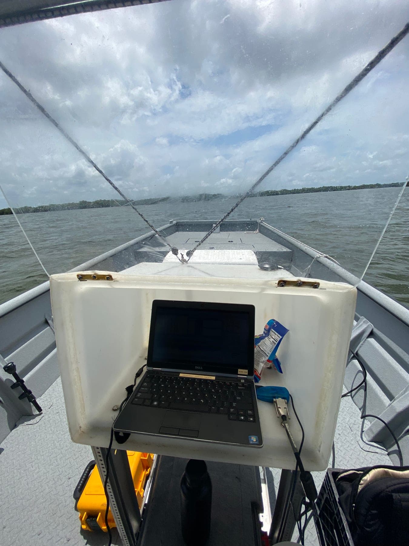
Shipboard acquisition station running during continuous cross-sectional transects.
Fig. 5Shipboard acquisition station running during continuous cross-sectional transects.
2016–2017Southwest Louisiana, USAcompleted

Coastal Salinity and Marsh-Response Modeling

Coupled 1D-2D modeling across a 400+ km² coastal domain to evaluate saltwater-intrusion and marsh-loss mitigation.

Modified, ran, and analyzed the domain along the southwest Louisiana coast to compare infrastructure alternatives. Prepared alternatives analyses, model summaries, visualizations, and briefings that translated results into defensible planning positions for engineers and the state coastal authority.

400+ km²
Domain
Coupled 1D-2D
Approach
2016–2017Southeast Louisiana, USAcompleted

Marsh Hydraulic Model Development and Calibration

Stood up a new marsh model end to end: survey design, field collection, calibration, and salinity alternatives.

Topo-bathymetric survey design, instrument-location planning, field data collection, calibration, and evaluation of salinity-management alternatives for a southeast Louisiana marsh system. A clear case of the pattern this practice is built on — collecting the measurements needed to constrain the model that informs the decision.

Survey to calibration
Scope
2017–2018Maryland and Mid-Atlantic, USAcompleted

Riverine Flood-Risk Mapping

~150 stream miles of hydraulic modeling for regulatory flood-risk mapping and post-hurricane hazard analysis.

Floodplain analysis supporting regulatory flood-risk mapping, infrastructure studies, and post-hurricane hazard assessment, paired with GIS automation that cut geospatial processing from hours to minutes and documentation and QA/QC prepared for regulatory review.

~150 stream miles
Extent
Hours to minutes
Automation gain

Data & Remote Sensing

3 projects
2024Coastal Georgia, USAcompleted

Deep-Learning Segmentation of Tidal Creek Networks

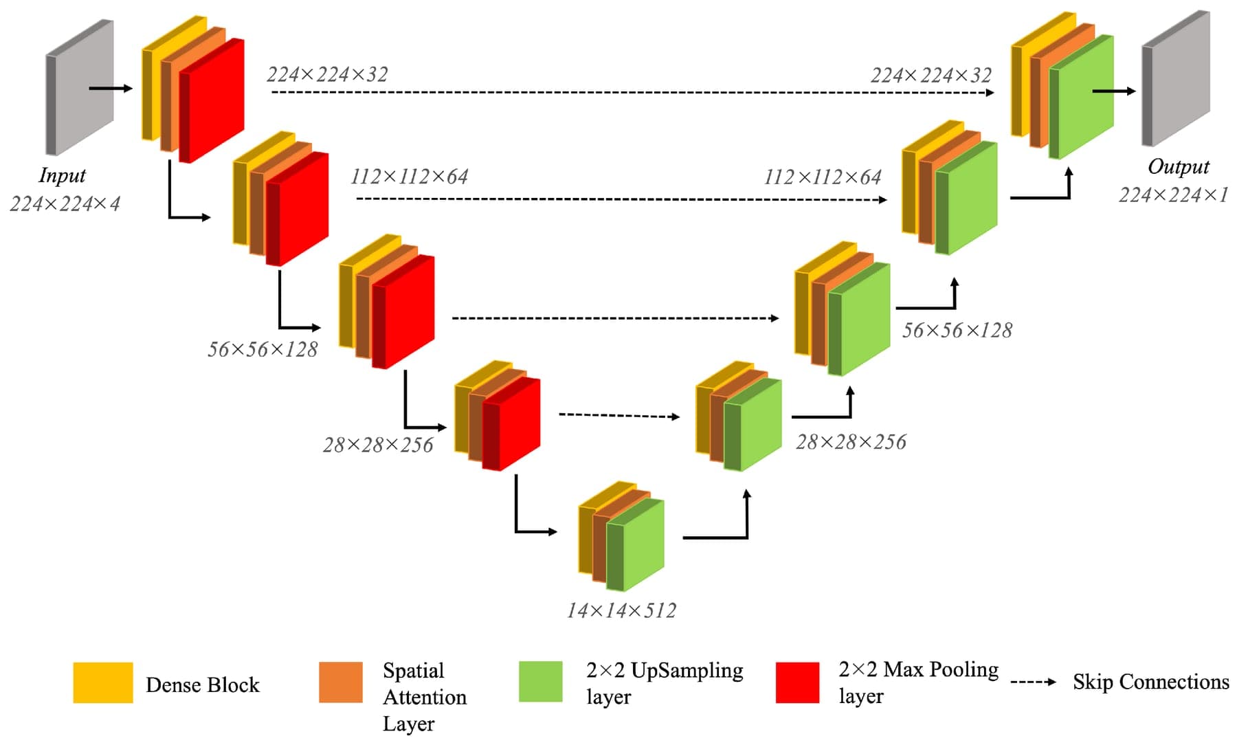
An attention-based Dense U-Net that segments tidal creek networks from 0.5 m aerial imagery at F1 = 0.98.

A co-authored method, applied across 255 km² of coastal marshland. It replaced labor-intensive manual GIS delineation and made landscape-scale analysis of creek and marsh co-evolution tractable.

255 km²
Extent
0.5 m
Resolution
0.98
F1 score
Read the publication
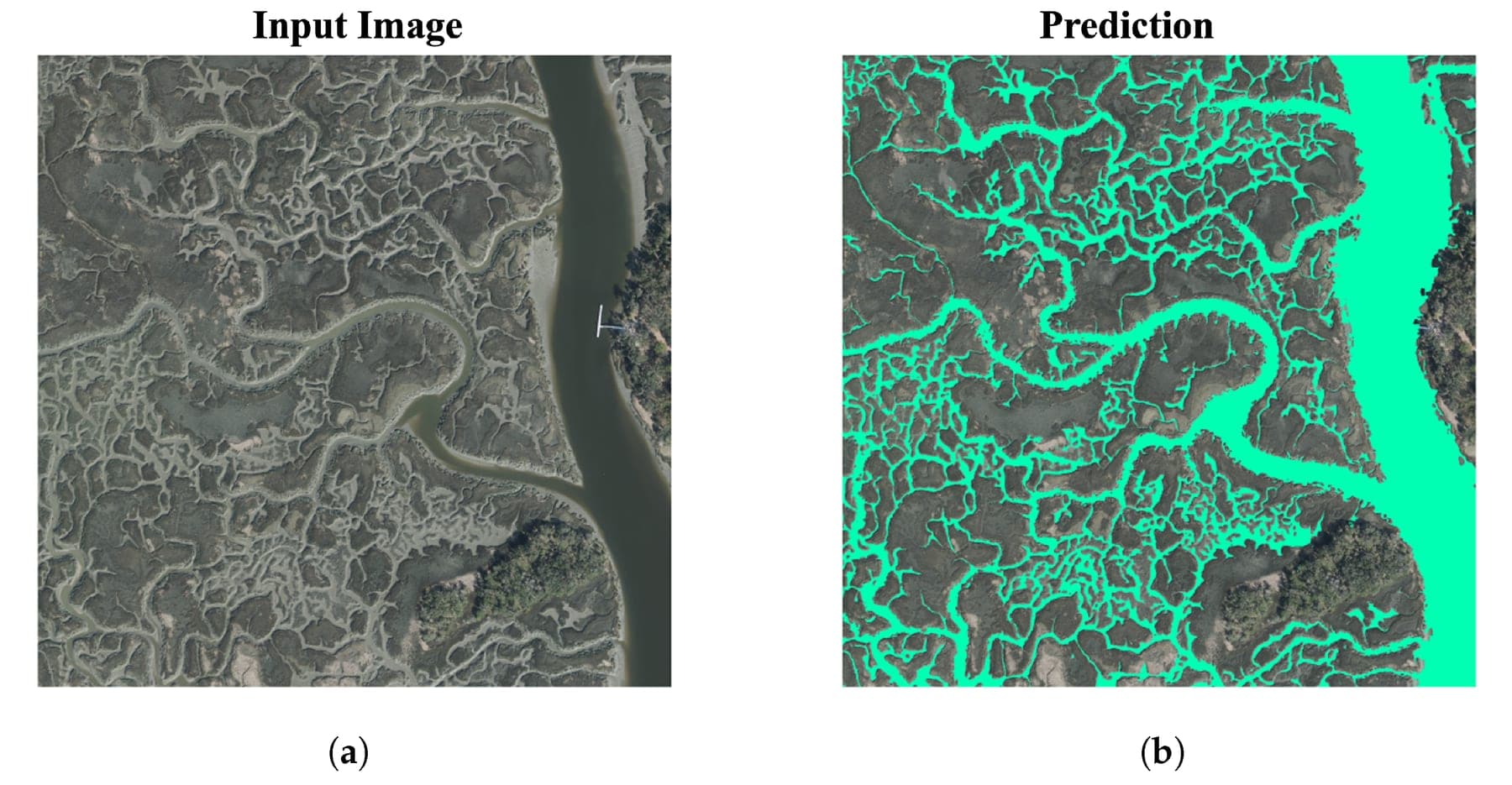
Input aerial imagery (left) against model prediction (right), showing automated creek-pixel classification at 0.5 m resolution.
Fig. 1Input aerial imagery (left) against model prediction (right), showing automated creek-pixel classification at 0.5 m resolution.
Dense U-Net architecture with spatial attention mechanisms, configured for high-resolution creek-network segmentation.
Fig. 2Dense U-Net architecture with spatial attention mechanisms, configured for high-resolution creek-network segmentation.
2018–2022Coastal Georgia, USAcompleted

Coastal Marsh Dynamics and Faunal Engineering

Multi-year field and remote-sensing research on marsh evolution, published in PNAS and Nature Communications.

Drone imagery, satellite remote sensing, boat-based measurement, and ecological observation on Georgia coastal marshes, used to understand marsh dynamics, creek evolution, and the interacting effects of sea-level rise and keystone grazer activity.

4 years
Duration
PNAS · Nat. Commun.
Venues
2015–2025Peruvian Amazon, Perucompleted

Amazon Anabranching Morphodynamics

Multi-decadal satellite analysis of channel migration and planform evolution in the upper Amazon.

Long-running collaborative research on anabranching structures in the Peruvian upper Amazon, including the confluence of the Marañón and Ucayali where the Amazon proper begins. Contributed to four peer-reviewed publications over a decade.

4
Publications
Multi-decadal
Span

Scientific Software

1 project
2022–2023Florida, USAcompleted

GPU Acceleration of Hydrodynamic Model Code

Ported ocean-model-derived scientific code to GPU, enabling rapid feasibility and risk assessment.

Worked alongside the lead engineer to port code derived from an established regional ocean modeling system, with support from a GPU vendor's higher-education program. The resulting speed-up makes feasibility assessment and risk analysis practical where full simulations were previously too slow to iterate on.

GPU / CuPy
Target

Work with a similar shape?

If a planning problem has outgrown its spreadsheet, or several good models need to become one defensible answer, that is the conversation worth having.